| State | qld |
|---|---|
| Coordinates | 28.48528°S 149.46806°E |
| Zoom | 8 |
| Postcode | 4496 |
| Area | 1718.9 |
| Dist 1 | 89.4 |
| Dir 1 | W |
| Location 1 | Goondiwindi |
| Dist 2 | 112 |
| Dir 2 | SE |
| Location 2 | St George |
| Dist 3 | 307 |
| Dir 3 | WSW |
| Location 3 | Toowoomba |
| Dist 4 | 438 |
| Dir 4 | WSW |
| Location 4 | Brisbane |
| Lga | Goondiwindi Region |
| Stategov | Southern Downs |
| Fedgov | Maranoa |
| Near-n | St George |
| Near-ne | North Bungunya |
| Near-e | Bungunya |
| Near-se | Boomi (NSW) |
| Near-s | Mungindi (NSW) |
| Near-sw | Mundingi (QLD) |
| Near-w | Daymar |
| Near-nw | Weengallon |
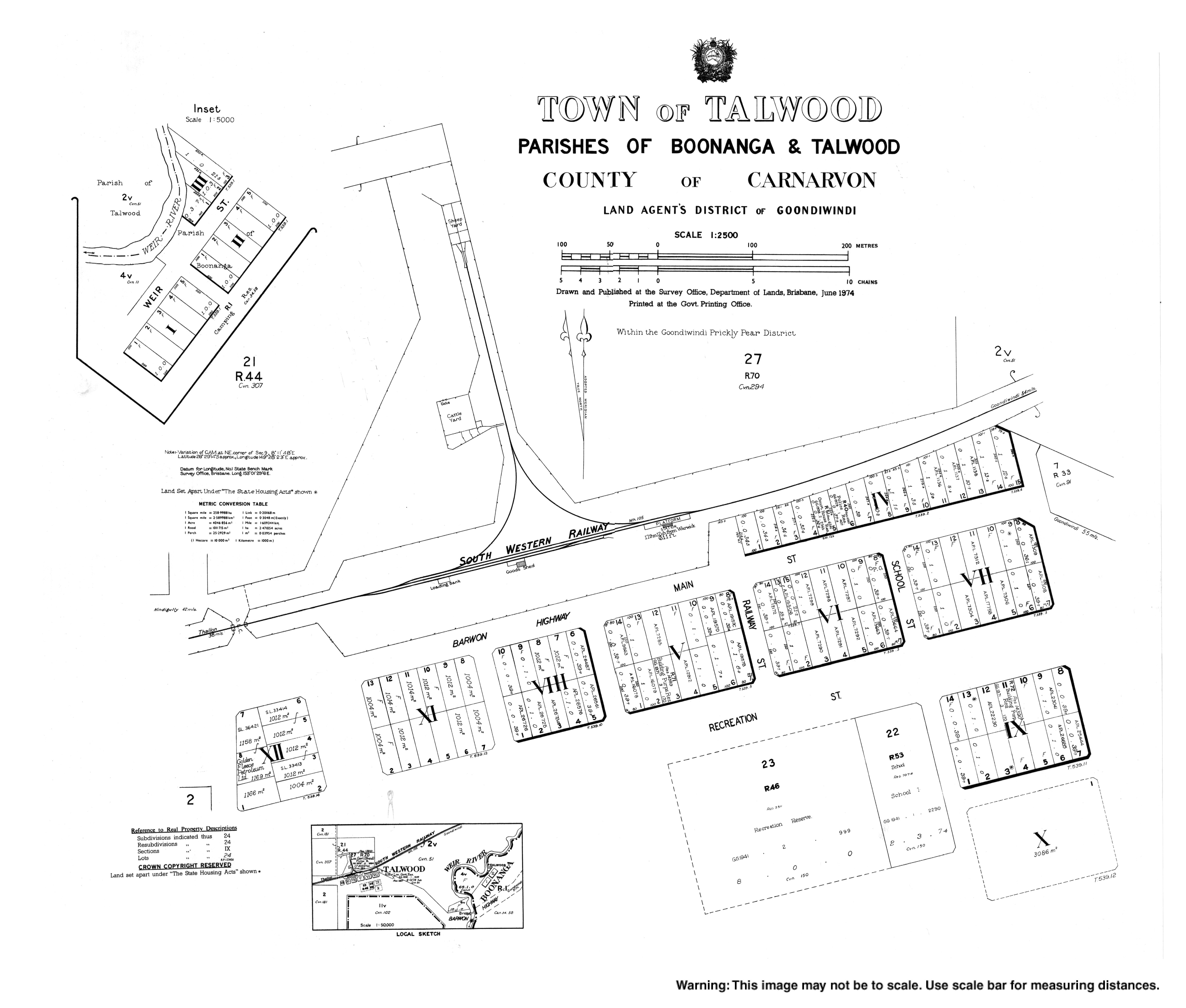
Talwood is a rural town and locality in Goondiwindi Region, Queensland, Australia.[1][2] It is on the border of Queensland and New South Wales, separated by the Macintyre River.[3]
On 17 May 2024, the Queensland Government decided to amalgamate the localities of North Talwood and South Talwood into a single locality called Talwood (with the already existing town of Talwood as its main urban area).[4][5][6]
Geography
The town lies in the south-east of the locality. Prior to the 2024 amalgamation, the town of Talwood was at the southern edge of the locality of North Talwood, immediately north of the boundary of South Talwood.[7]
The Macintyre River forms the southern boundary of the locality, separating Queensland from New South Wales.[3]
The Barwon Highway enters the locality from the east (Bungunya), passes just north of the town, and exits to the north-west (Weengallon).[8]
The South-Western railway line also enters the locality from the east (Bungunya) just south of the highway. The town is served by Talwood railway station (28.4846°S 149.4683°E) on the northern edge of the town. The railway line exits to the west (Weengallon / Daymar).[7][9] There are three other railway stops on the line within the locality (from west to east):[8]
- Gradule railway station in the south-west of the locality (28.54°S 149.2128°E)[10]
- Talwood Wheat railway siding immediately west of the town (28.48561°S 149.45764°E)[8]
- Lalaguli railway station, now abandoned, in the east of the locality (28.4498°S 149.5785°E)[10]
History
Gamilaraay (Gamilaroi, Kamilaroi, Comilroy) is a language from South-West Queensland and North-West New South Wales. The Gamilaraay language region includes the landscape within the local government boundaries of the Balonne Shire Council, including the towns of Dirranbandi, Thallon, Talwood and Bungunya as well as the border towns of Mungindi and Boomi extending to Moree, Tamworth and Coonabarabran in New South Wales.[11]
The town's name is believed to be a corruption of Dalwood, a pastoral run name used from 1844, which was believed to be derived from an Aboriginal word. In 1903, it was spelled Tallwood on a survey plan with an annotation that it has been altered to Talwood, a name which was shown on a 1911 survey plan.[1]
Tallwood Provisional School opened in 1911, but closed in the same year. Talwood State School opened on 4 November 1918.[12] A new state school was built and opened in June 1945.[13]
Talwood Presbyterian Church was opened at 7 Main Street (28.485113°S 149.4712°E) on 21 December 1947.[14] It was built from timber. Following the amalgamation that created the Uniting Church in Australia in 1977, it became Talwood Uniting Church. It closed circa 1990 and is now used as a house.[15]
The Talwood branch of the Queensland Country Women's Association opened in 1949.[16]
St Paul's Anglican Church was built in 1956. It was built to be a memorial for those who served in World War II. The brick church was designed by Edwin Hayes in the Modernist style to seat 80 people.[17]
St Joseph's Catholic Church was built from timber in 1955 at 14 Recreation Street (28.486046°S 149.4707°E). It is now closed, but, as at 2024, the church building is still extant.[18][19]
On 17 May 2024, the Queensland Government decided to amalgamate the localities of North Talwood and South Talwood into a single location called Talwood (with the town of Talwood as its main urban area).[4][5][6]
Education
Talwood State School is a government primary (Prep-6) school for boys and girls at 17 Recreation Street (28.4866°S 149.4703°E).[20][21] In 2018, the school had an enrolment of 28 students with four teachers (three full-time equivalent) and five non-teaching staff (two full-time equivalent).[22]
There are no secondary schools in Talwood. The nearest government secondary school is Goondiwindi State High School in Goondiwindi to the east, but due to the distance, other options would be distance education and boarding school.[23]
Amenities
Talwood Post Office is at 25 Main Street (28.4854°S 149.4692°E).[24]
St Paul's Anglican Church is at 2 Main Street (28.484544°S 149.4717°E).[17] As at 2024, services are only held at the church "on request".[25]
References
- ^ Retrieved 4 July 2017.
- ^ Retrieved 20 July 2024.
- ^ "Layers: Locality; State border; Mountains and ranges; Contours; Watercourse". Queensland Globe. Queensland Government. Retrieved 25 March 2026.
- ^ "Current proposals and decisions | Place names". Environment, land, and water. Queensland Government. Archived 21 June 2023 at the Wayback Machine. Retrieved 2024-07-20.
- ^ "Proposed locality: Talwood, Goondiwindi Region (shows boundaries of North Talwood and South Talwood)". Environment, land and water. Queensland Government. 29 September 2023. Archived 20 July 2024 at the Wayback Machine. Retrieved 20 July 2024.
- ^ "Locality of Talwood within the Goondiwindi Local Government Area". Environment, land and water. Queensland Government. 17 May 2024. Retrieved 20 July 2024.
- ^ Retrieved 23 October 2020.
- ^ "Layers: Locality; Road and rail". Queensland Globe. Queensland Government. Archived 19 December 2017 at the Wayback Machine. Retrieved 21 July 2024.
- ^ "Railway stations and sidings - Queensland". Queensland Open Data. Queensland Government. 27 August 2020. Archived 5 October 2020 at the Wayback Machine. Retrieved 5 October 2020.
- ^ "Railway stations and sidings - Queensland". Queensland Open Data. Queensland Government. 2 October 2020. Archived 5 October 2020 at the Wayback Machine. Retrieved 5 October 2020.
- ^ "Indigenous Language map of Queensland". State Library of Queensland. Archived 2 September 2020 at the Wayback Machine. Retrieved 23 January 2020.
- ^ Queensland Family History Society (2010), Queensland schools past and present, Version 1.01 ed., Queensland Family History Society, ISBN 978-1-921171-26-0
- ^ "The South-West". Warwick Daily News. No. 8065. 6 June 1945. p. 2. Retrieved 21 July 2024. – via National Library of Australia.
- ^ "Presbyterian Churches On The Downs - Downs Folk". Lives and times of folk of Toowoomba & the Downs. Archived 26 July 2024 at the Wayback Machine. Retrieved 2024-07-21.
- ^ Blake, Thom. "Talwood Presbyterian Church". Queensland Religious Places. Archived 21 July 2024 at the Wayback Machine. Retrieved 2023-06-23.
- ^ "NEWS ITEMS FROM CITIES AND TOWNS". The Courier-mail. No. 4045. 12 November 1949. p. 7. Retrieved 21 July 2024. – via National Library of Australia.
- ^ Blake, Thom. "St Paul's Anglican Church". Queensland Religious Places. Retrieved 2023-06-23.
- ^ Blake, Thom. "St Joseph's Catholic Church". Queensland Religious Places. Archived 21 July 2024 at the Wayback Machine. Retrieved 2023-06-23.
- ^
- ^ "State and non-state school details". Queensland Government. 9 July 2018. Archived 21 November 2018 at the Wayback Machine. Retrieved 21 November 2018.
- ^ "Talwood State School". Talwood State School. 2020-11-29. Retrieved 2023-02-15.
- ^ "ACARA School Profile 2018". Australian Curriculum, Assessment and Reporting Authority. Archived 27 August 2020 at the Wayback Machine. Retrieved 28 January 2020.
- ^
- ^ "Talwood LPO". Australia Post. Archived 28 November 2020 at the Wayback Machine. Retrieved 2020-12-27.
- ^ "Our Churches". Anglican Parish of Goondiwindi. Archived 13 October 2024 at the Wayback Machine. Retrieved 2024-07-21.