| Translit lang 1 | Arabic |
|---|---|
| Arabic | بيت أمين |
| Coordinates | 32°07′52″N 35°01′13″E |
| State | State of Palestine |
| Governorate | Qalqilya |
| Unit pref | dunam |
| Elevation | 99 m |
| Population total | 1279 |
| Population as of | 2017 |
| Name meaning | Khurbet Beit Yemin=The ruin of the house of Yemin, p. n.[1] |
Beit Amin (Arabic: بيت أمين) is a Palestinian village in the Qalqilya Governorate in the western West Bank, located south of Qalqilya. According to the Palestinian Central Bureau of Statistics, the village had a population of 1,279 inhabitants in 2017.[2]
Location
Beit Amin is located 8.35 km south-east of Qalqiliya. It is bordered by Sanniriya to the east, Al Mudawwar and ‘Izbat al Ashqar to the south, ‘Izbat Salman to the west, and ‘Azzun ‘Atma to the north.[3]
History
In 1882 the PEF's Survey of Western Palestine noted Khurbet Beit Yemin (under "Archæology"): "Walls, cisterns and rock-cut tomb."[4]
British Mandate
The village passed to British control they defeated the Ottoman Empire in World War 1. The village was administered under the British Mandate for Palestine until 1948.
Jordanian Era
In the wake of the 1948 Arab–Israeli War, and after the 1949 Armistice Agreements, Beit Amin came under Jordanian rule.
Post-1967
Since the Six-Day War in 1967, Beit Amin has been under Israeli occupation.
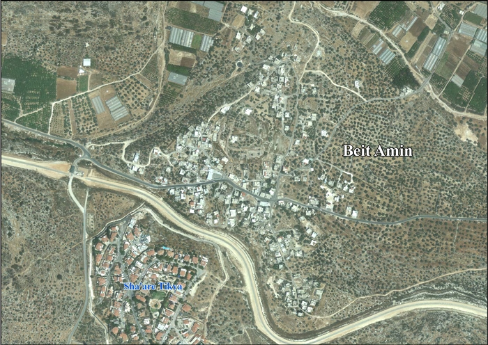
After the 1995 accords, about 29.2% of village land was classified as Area B, the remaining 70.8% as Area C. Israel has confiscated land from Beit Amin, ‘Azzun ‘Atma and Mas-ha in order to construct the Israeli settlement of Shi'ar Tikvah. In addition, the Israeli West Bank barrier will isolate some of Beit Amins village land behind the wall.[5]
References
- ^ Palmer, 1881, p. 232
- ^ Preliminary Results of the Population, Housing and Establishments Census, 2017. State of Palestine. February 2018. pp. 64–82. Retrieved 2023-10-24.
- ^ Beit Amin village profile, ARIJ, 2013, p. 4
- ^ Conder and Kitchener, 1882, p. 329
- ^ Beit Amin's village profile, ARIJ, 2013, pp. 15-16
Bibliography
- Conder, C.R. & Kitchener, H.H. (1882). The Survey of Western Palestine: Memoirs of the Topography, Orography, Hydrography, and Archaeology. Vol. 2. London: Committee of the Palestine Exploration Fund
- Palmer, E.H. (1881). The Survey of Western Palestine: Arabic and English Name Lists Collected During the Survey by Lieutenants Conder and Kitchener, R. E. Transliterated and Explained by E.H. Palmer. Committee of the Palestine Exploration Fund
External links
- Welcome to Beit Amin
- Survey of Western Palestine, Map 14: IAA, Wikimedia commons
- Beit Amin village (fact sheet), Applied Research Institute–Jerusalem, ARIJ
- Beit Amin village profile, ARIJ
- Beit Amin, aerial photo, ARIJ
- Development Priorities and Needs in Beit Amin, ARIJ
- Subterranean Wells of Jayyus and Beit Amin villages in Qalqiliya governorate-swamped with waste dumped by Israeli settlers 12, February, 2007, ARIJ